Mera Peak & Island Peak Climbing Expedition
| Trip code | |
| Package name | Mera Peak & Island Peak Climbing Expedition |
| Duration | 31 |
| Max. elevation | 6461 m |
| Level | Moderate |
| Transportation | Domestic flight and all ground transportation as per the itinerary |
| Accomodation | Hotel in Kathmandu and a Tea House / Lodge / Camp during the trek |
| Starts at | Kathmandu |
| Ends at | Kathmandu |
| Trip route | |
| Cost | USD 7,060 per person |
Highlights
- Summit two iconic Himalayan peaks: Mera Peak (6,476m), Island Peak (6,189m)
- Cross the technical Amphu Laptsa Pass (5,845m) between the Makalu & Everest regions
- Traverse legendary Everest high pass: Kongma La (5,535m)
- Remote trekking through Upper Hinku Valley
- Glacier travel, ice climbing, fixed ropes & crevasse navigation
- Panoramic views of Everest, Lhotse, Makalu, Cho Oyu, Nuptse & Ama Dablam
- Explore Makalu-Barun National Park, Khumbu Valley
- Visit Everest Base Camp and a sunrise hike to Kala Patthar
- Return journey through the Everest Base Camp route with visits to iconic viewpoints and villages
- Full expedition experience: lodge trekking + high-altitude tented camping
- Pre-climb training for all three peaks
- Led by experienced, certified mountain guides
- Ideal preparation for 7000m–8000m Himalayan expedition
- A combination of lodge stays and remote tented camping with full expedition support
- Two reserve days in Kathmandu for safety, weather flexibility, and recovery.
Overview
This is a true high-altitude Himalayan expedition, linking two iconic peaks—Mera Peak (6,461m) and Island Peak (6,189m)—through the legendary Amphu Lapcha Pass (5,845m), one of the most challenging crossings in Nepal. The journey pushes deep into the remote Hinku and Hongu valleys, far from the usual trekking routes, where the landscape becomes increasingly wild, glaciated, and demanding. Days are marked by glacier travel, steep ascents, and technical sections that test endurance, skill, and determination at extreme altitude. Along the way, the route opens beneath a dramatic skyline of Himalayan giants, with unforgettable views of Everest, Lhotse, Makalu, Cho Oyu, and Kanchenjunga rising above the horizon. The expedition ends with the demanding crossing of Amphu Lapcha Pass—a high, exposed, and technical gateway between the Imja and Hongu valleys—marking one of the defining challenges of the entire journey.
Trip Preparation
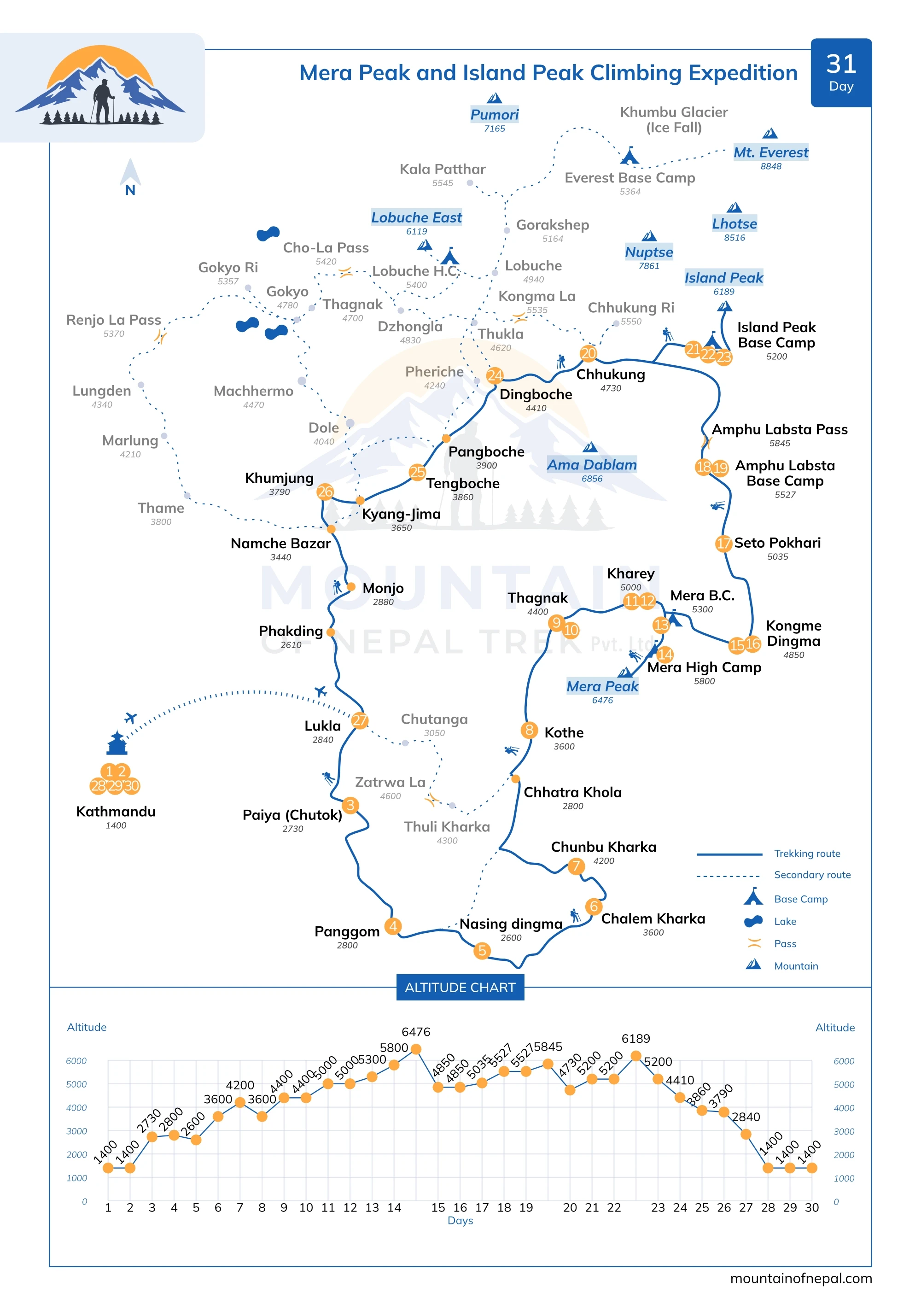
Trip Itinerary
Day 1 : Arrival in Kathmandu (1,400 m)
Upon arrival at Tribhuvan International Airport, you will be warmly welcomed by a representative from Mountain of Nepal Trek and transferred to your hotel in Kathmandu. After check-in, the rest of the day is free to rest and recover from your international flight. If time permits, you may explore Thamel, Kathmandu’s lively tourist district, known for trekking shops, cafés, restaurants, and local handicrafts. In the evening, enjoy a welcome dinner at a traditional Nepali restaurant, where you will experience authentic cuisine and meet your guide for a brief introduction before the expedition begins. Accommodation: Hotel , Meals: Welcome Dinner
Day 2 : Preparation Day – Permits, Gear Check & Briefing
Today is an essential preparation day for your Mera & Island Peak Climbing expedition. The day begins with a detailed briefing from your climbing guide, where you will review the full Mera & Island Peak climbing itinerary, trekking and climbing route, altitude challenges, safety guidelines, and overall expedition plan. Along with your climbing guide, you will also meet your climbing team and gain a clear understanding of how the journey will be organized from start to summit and return. A complete gear check follows to ensure you are fully prepared for high-altitude conditions. Your guide will inspect all trekking and climbing equipment, including boots, crampons, harness, helmet, sleeping bag, clothing layers, backpack, and other essentials. If anything is missing or needs adjustment, equipment can be rented or purchased in Thamel, Kathmandu. The rest of the day is free for rest, finally shopping in Kathmandu, or personal preparation at your own pace. This preparation day ensures everything is in place—logistically, physically, and mentally—so you can begin your journey into the Himalayas with confidence, clarity, and peace of mind.
Day 3 : Fly to Lukla (2800m) and trek to Puiyan (2800m) walk approx5-6 hrs
Start your Mera and Island Peak climb with an early morning scenic flight to Lukla, operating either from Kathmandu (approx. 35 minutes) or Manthali Airport in Ramechap (approx. 20 minutes), depending on the season. This short mountain flight offers breathtaking views of the Himalayas, including snow-capped peaks and deep valleys, before landing at the famous Tenzing–Hillary Airport, where your trekking crew will welcome you. The guides and porters will collect your luggage, and once everything is packed and ready, you will set off on today’s walking journey. You begin with a descent from the airstrip down a scenic mountain trail toward the Surke Khola River. It is a beautiful downhill walk through natural terrain, with the river guiding us toward the larger Dudh Kosi, known for its fast-moving glacial waters. The trail then follows old trading routes used for generations. We pass small mountain villages where locals farm the land, growing crops like millet, corn, and buckwheat for daily life. As we continue our journey, we gradually ascend again. The elevation changes, and the landscape transforms as the trail enters the lush Himalayan Forest. Open fields give way to peaceful woodland filled with oak, maple, and rhododendron trees, creating a quiet and refreshing trekking environment. Overnight in a lodge in Puiyan.
Day 4 : Paiya to Panggom – 2,800m | walk approx. 5–6 hrs
After your first breakfast in the mountains, you begin walking along a well-marked main trekking trail for a short distance before turning onto a quieter forest path. This section can sometimes be less defined and requires careful attention as you move deeper into a more remote and natural landscape. Gradually, the route becomes more isolated as you traverse a series of ridges toward the Khari Khola valley. Although the altitude remains similar to the previous day, the trail is not flat. You steadily ascend and descend across two main passes: Chutok La (2,945m) and Khari La (3,080m). These passes are not very high, but they make the day more physically engaging with continuous ups and downs. As you approach Pangum, the trail enters a quiet, bowl-shaped valley just below Pangum La. The surroundings become increasingly peaceful, with dense forests of rhododendron, pine, and oak. This is a less-traveled route, so you will encounter very little foot traffic, mostly limited to local villagers. Finally, you arrive at Pangum, a traditional and historic village that remains largely untouched by modern development. Stone-built houses line the hillside, and a newly built monastery (gompa) sits above the settlement, with prayer flags and prayer wheels reflecting the region’s spiritual heritage. From the village, wide views open across the surrounding valley and distant ridgelines. Overnight in a lodge in PuiyanPanggom.
Day 5 : Panggom to Nashing Dingma (2600m)- 7 hours
Today’s journey begins with a short but rewarding climb to Pangum La (3,175m), where the route opens into the dramatic entrance of the beautiful Hinku Valley. From the pass, you get your first view of Mera Peak. The trail then turns east and then north, leading you deeper into less-traveled Himalayan terrain. You then descend sharply to the Hinku River—a long but rewarding drop through changing landscapes. The descent can be steep and demanding on the knees, so trekking poles can be a valuable companion. After reaching the valley floor, the route climbs steadily again toward a high camp near Surke La, offering a true sense of adventure and accomplishment. This is a true expedition day—marked by significant elevation loss and gain—that helps build strength for the higher altitudes ahead. Throughout the day, you’ll experience a rich mix of scenery—from cultivated slopes with traditional grain farming to thick rhododendron forests mixed with pine and scattered fir—making this one of the most varied and rewarding sections of the trek. Overnight at a lodge or camp in Nashing Dingma.
Day 6 : Nashing Digma to Chalem Kharka (3600m).5-6 hours
From your camp, you ascend until you reach a beautiful mountain pass called Surke La (3,085m). From the pass, you continue for about another hour before stopping at a suitable point for lunch, as there are no reliable water sources along this exposed section of the Surke Danda ridge. After the lunch break, the trek continues along the Surke Danda ridge, gradually heading north into a quieter and more remote part of the Himalayas. This scenic ridge walk is covered with thick bamboo and rhododendron forests, and the trail gradually leads you deeper toward the Hinku Valley and in the direction of Mera Peak. This section is remote and off the main trekking routes, with no teahouses, making it feel like true wilderness trekking. The landscape becomes increasingly wild and untouched as you move further into the mountains. Continuing deeper into the wilderness, you eventually arrive at your campsite at Chalem Kharka, a seasonal yak grazing area used by lowland communities. Overnight in a tented camp.
Day 7 : Chalem Kharka to Chunbu Kharka (4200m), 4 -5 hours
A challenging day today as we traverse two dramatic high passes at approximately 4,200m and 4,450m before descending to our campsite. After breakfast, we begin the ascent to the first pass at around 4,200m, taking approximately two hours of steady climbing along the ridge. As we gain height, the views open up dramatically across the valley, and on the far side, we can even spot the route over Zatra La, leading back toward Lukla. At the top of the first pass, the scenery expands further, revealing sweeping views of the Kanchenjunga range, where the towering peak of the world’s third-highest mountain dominates the horizon in a truly unforgettable panorama. From the pass, we continue the ascent toward the second pass at 4,450m, which is reached in about another two hours. At this altitude, the landscape becomes fully alpine—no forests, only vast grassy slopes, stone ridges, and dramatic cliffs. This is also a good area for spotting wildlife, including birds of prey such as griffon vultures, lammergeiers, and eagles soaring overhead. A short descent then leads to the sacred Panch Pokhari lakes, a cluster of five alpine pools where Hindu pilgrims visit during seasonal festivals. From the lakes, a steady 30-minute descent brings us to our campsite at Chunbu Kharka (around 4,200 m).
Day 8 : Trek into Hinku Valley – Reach Kote (3,600 m) | 6–7 hrs
Today’s trek takes you deeper into the Hinku Valley, entering more remote and scenic terrain as you approach Kote. The day begins with a steady ascent to a ridge at around 4,400 m, followed by a long traverse along the eastern side of the valley. The trail then gradually descends through dense rhododendron forest, with some sections of loose, rocky terrain, leading to a lunch stop after approximately 4 hours of walking. After lunch, the trail continues for around 3 hours, descending deeper into the valley. As you descend further, the sound of the river gradually grows stronger. Along the way, the landscape opens up to a striking natural feature—a wide erosion scar above the Hinku River. This area was significantly shaped by a major flood event in 1998, when Sabai Tsho breached its moraine dam, significantly reshaping the valley’s landscape. The route then continues to a river crossing via a suspension bridge before reaching Kote. This peaceful campsite is set on a grassy terrace above the river, surrounded by forest and mountain scenery. Overnight: at the lodge in Kote.
Day 9 : Kothe to Thaknak – 4,400m | walk approx. 5 hrs
Today, you enter the high alpine zone as the trail leads deeper into the Hinku Valley. The landscape becomes more open and rugged, and the surrounding peaks feel much closer, creating a true high-mountain experience. The morning begins with a steady walk along the river on a rocky trail, with a gradual ascent through the valley. As you gain elevation, the terrain opens up, offering impressive views of Kyashar (6,769m) and Kusum Kanguru (6,367m. Leaving the river valley behind, the trail climbs gently toward wide alpine yak pastures (kharka), where the scenery becomes broader and more dramatic. After approximately 3 hours, you reach a suitable lunch stop. From here, you have the option to take a short detour to a small cave monastery located above the main trail. While simple, it offers insight into local culture and a peaceful mountain setting. The trek continues for another 2 hours toward Thagnak, following a gradual ascent through increasingly rugged terrain. Basic tea houses can be found along the route, though facilities remain simple compared to the Everest main trail. By the time you reach Thagnak, you are fully in the high mountain environment, surrounded by open valley landscapes and towering peaks—an important step in your acclimatization and journey toward Mera Peak. Overnight: Teahouse / Lodge in Thagnak
Day 10 : Acclimatization day in Thaknak – 4,400m
Today, you make an acclimatization hike to a viewpoint at approximately 5,100 m. The route involves a steady climb up the grassy ridge rising behind Thagnak. This acclimatization hike follows the “climb high, sleep low” approach, allowing your body to adjust effectively before heading to higher elevations. The round trip takes around 5–6 hours, depending on weather, trail conditions, and walking pace. At the top, the effort is well rewarded with stunning views of Mera Peak, Kyashar, and Kusum Kanguru, rising dramatically above the surrounding landscape. The high-altitude setting offers a true sense of being deep in the Himalayas. After a short rest, you descend back to Thagnak. This is not a summit day, but it is a critical part of the expedition, helping build the strength and altitude adaptation needed for a safe and successful climb of Mera Peak.
Day 11 : Thaknak to Khare – 5,000m | walk approx. 4-5 hrs
The trek begins through a rough, rocky section where walking becomes slower and more challenging due to the rugged terrain and scattered large boulders. After about one hour of walking, the path briefly detours from the main trail and leads to Sabai Tsho (glacial lake area), a significant natural and historical site formed after the flood event. This area was shaped by a major flood event in 1998, when the Sabai Tsho glacial lake burst its natural moraine dam, sending a sudden flood through the Hinku Valley and reshaping the landscape that still exists today. From here, the journey continues deeper into the valley toward Dig Kharka, reached after around three hours of steady trekking. After a short break and lunch, the final ascent begins. The trail climbs gradually for about an hour before reaching Khare, the main base camp for Mera Peak, set beneath the vast surrounding peaks of the Hinku region
Day 12 : Pre-Climb Training at Khare (5,000m)
Before the summit push of Mera Peak, a pre-climb training session is conducted at Khare. This essential preparation helps climbers refresh key mountaineering skills and build confidence for high-altitude peak climbing. With guidance from our experienced climbing guides, you will learn the essential techniques required for glacier travel and high-altitude climbing. This includes the correct use of crampons, harness, ice axe, and rope systems in alpine conditions. You will also train in rope team movement across snow and glacier terrain, including safe ascent and descent procedures, practicing balance, coordination, and mountain safety. The session includes an introduction to basic self-arrest techniques, building confidence, and readiness for the challenges of Mera Peak climbing. This hands-on session ensures climbers are well-prepared for the technical sections of Mera Peak, including glacier travel and high-altitude movement, improving both safety and summit success chances. Overnight at a tented camp
Day 13 : Climb to Mera La (5,300m)-walk approx. 4hours
Today’s climb begins with a steady ascent over a moraine ridge, followed by a steeper scree slope as you gain height above the valley. The trail continues toward the snout of the glacier, taking approximately two hours.
From here, the nature of the climb changes, and the real high alpine section begins. You gear up with crampons and a harness before stepping onto the ice. After preparation, a short climb over icy terrain leads you onto a broad glacial plateau. The route then continues across the glacier toward Mera La (5,300m), which offers spectacular panoramic views of Himalayan giants, including Mount Everest, Makalu, Kanchenjunga, Lhotse, Nuptse, Chamlang, and Baruntse on clear days. As there are no designated camping areas at the pass itself, you descend approximately 20–30 minutes to the eastern side to find a suitable place to set up camp on rocky terrain, often covered with snow. Overnight: Tented Camp
Day 14 : Climb to High Camp (5,800m) – Mera Peak Expedition-3-4 hrs
Leaving Mera La behind, you begin the climb to Mera High Camp, following the route along the rocky north flank. The trail gradually gains elevation over a mix of snow, ice, and loose terrain, becoming more exposed as you move higher and requiring a steady, controlled pace. After a 3-4 hour climb, you reach Mera High Camp (5,800m), set on a narrow ridge with outstanding Himalayan views. On clear days, peaks such as Everest, Makalu, and Kanchenjunga dominate the skyline. From this elevated position, tomorrow’s summit route becomes clearly visible, leading across the glacier toward the upper slopes of Mera Peak. At High Camp, you rest, hydrate, and prepare equipment for the early morning summit push. An early dinner is taken before resting for the night. Overnight: Tented Camp
Day 15 : Summit Day – Mera Peak (High Camp → Summit → Kongma Dingma) (4,800m). Walk aprox.10-12 hrs
The summit push begins in the early hours of the morning, typically around 2:00–3:00 AM, when conditions are most stable. With a headlamp, you leave High Camp and step onto the frozen slopes of the Mera Glacier. The ascent follows a broad snowfield, climbed at a slow, steady pace in rope teams. Although non-technical, the climb is physically demanding due to deep snow and high altitude. Reaching the summit usually takes 4–6 hours, depending on conditions. As you gain height, the terrain opens into a vast glacial landscape leading toward the final ridge. Due to the unstable nature of the northern summit knob, the ascent is typically made to the central summit (6,461m), offering a safer and more reliable route. From the top, enjoy outstanding panoramic views of Everest, Makalu, Kanchenjunga, Lhotse, and Cho Oyu. After a short time at the summit, you descend carefully to High Camp, rest briefly, and continue down into the Hinku Valley to Kongma Dingma (4,800m). Overnight: Tented Camp
Day 16 : Contingency Day (Spare Summit Day) – 5,000m
This day is reserved as a contingency to provide flexibility for the summit attempt of Mera Peak. In the high Himalayas, weather conditions can change quickly, and factors such as strong winds, snowfall, or poor visibility may delay climbing plans. This additional day allows for a safer and more flexible summit window if needed. If the summit has already been achieved, the day can be used for rest and recovery, allowing time to relax after the physical demands of the climb. It also provides flexibility in case of delays or changes to domestic flights in the Everest region. Overnight: Tented camp
Day 17 : Kongma Dingma to Seto Pokhari (5,035m) Upper Hinku Valley. Walk approx.5–6 hours
Today’s trek continues through the remote Upper Hinku Valley, gradually ascending toward Seto Pokhari (5,035m), also known as the “White Lake.” The trail crosses glacial debris, rocky slopes, and wide alpine terrain, offering a true wilderness experience in one of the most isolated regions of the Himalayas. Seto Pokhari lies beneath towering peaks, including Chamlang (7,319m) and Baruntse (7,129m). This remote and dramatic setting is a common campsite for expeditions preparing to cross Amphu Labtsa Pass or continue toward the Barun Valley. Overnight: Tented Camp
Day 18 : Seto Pokhari to Amphu Labtsa Base Camp (5,527m) | 4–5 hours
Leaving Seto Pokhari behind, the trail enters a raw and isolated world of high alpine wilderness. The route climbs and contours through rugged terrain, crossing glacial moraines, loose scree, and occasional icy sections where every step demands focus and care. Surrounded by towering Himalayan walls and wind-swept ridgelines, you continue deeper into this completely uninhabited wilderness. The sense of isolation grows stronger with every step as the valley narrows and the terrain becomes more demanding. Beneath massive peaks and shifting cloud lines, you continue toward Amphu Labtsa Base Camp. This is true expedition terrain—remote, silent, and shaped entirely by altitude and weather. The guide team carefully manages the route, pacing, and camp selection, which will depend on water availability and mountain conditions. The base camp is set on stark rocky ground below Amphu Labtsa Pass at around 5,527m, marking a critical staging point before the technical crossing into the Imja Valley. Overnight: Tented Camp
Day 19 : Acclimatization Day at Amphu Labsta Base Camp
A crucial pause in the expedition. After several demanding days, your body needs time to adjust before the final high pass. You may take a short acclimatization walk above camp, gaining height before returning to rest. The rest of the day is spent preparing gear, hydrating, and conserving energy. The silence of the high mountains surrounds you—tomorrow will demand everything. Overnight: Tented Camp
Day 20 : Cross Amphu Lapcha Pass (5,845m) descend to Chhukung (4,730m) – 9–10 Hours
The ascent to Amphu Lapcha Pass is steep, technical, and highly demanding, involving sections of rock, ice, and snow. Fixed ropes are used in exposed areas to ensure safety and steady progress. Step by step, we move higher into a dramatic high-altitude landscape surrounded by glaciers and towering Himalayan peaks. Reaching the summit of the pass is a powerful and unforgettable moment—standing at 5,845 meters between two major mountain regions, with vast panoramic views stretching across the Himalaya. The descent on the other side is equally challenging. Steep and exposed sections require careful rope-assisted movement and full concentration from the entire team. As we continue descending, the terrain gradually softens and opens into the Imja Valley. Signs of the Everest region begin to appear again—well-defined trails, trekkers, and distant lodges returning into view. By the time we reach Chhukung (4,730m), the journey is complete. After days in remote and extreme high-altitude terrain, we return to a more familiar trekking environment, with the comfort of a lodge and the deep satisfaction of completing one of the Himalaya’s most challenging crossings. Overnight -lodge
Important Expedition Note
We make an alpine start, often before sunrise or even in the middle of the night. Guides assist team members and porters in carrying loads across difficult and technical terrain. High-altitude crossings involve serious objective risks such as snow, ice, avalanches, and hidden crevasses. For safety, lighter loads are carried to reduce the risk of slips and accidents. The descent is more challenging, often steep and icy. All equipment—including luggage, food, tents, and other logistics supplies—is transported across using fixed rope systems. All staff, porters, and team members also descend carefully using fixed ropes for safety.
Day 21 : Chhukung to Island Peak Base Camp (5,200m, walk approx. 3-4 hours
Leaving Chhukung, the trail leads deeper into the Imja Valley, steadily gaining altitude as it moves through open alpine terrain. The surroundings become increasingly rugged and remote, with expansive views of the surrounding Himalayan giants and a growing sense of high-altitude isolation. The trail first ascends steeply before contouring along the valley floor, following the moraine of the Lhotse Glacier. The route then becomes more gradual, with a pleasant section alongside a stream as you approach the upper valley. A final push leads to Base Camp, typically reached by late morning or lunchtime. Here, you arrive in a wide, open basin beneath Island Peak, where camp is set for rest and preparation at high altitude. This is the staging point for your Island Peak climb, where the focus shifts to rest, acclimatization, and preparation. Overnight at a tented camp.
Day 22 : Rest, Preparation & Briefing at Island Peak Base Camp (5,200m)
After several days spent in the high-altitude Himalayan environment, including the ascent of Mera Peak and the demanding crossing of the technical Amphu Labtsa Pass, today is dedicated to rest, recovery, and preparation for the next climb of Island Peak. Your guides provide a full route briefing for Island Peak, including an overview of the climbing route, summit strategy, and safety procedures for the ascent and descent. A light technical refresh is conducted where needed, focusing on rope movement, glacier travel reminders, and equipment checks to ensure everything is ready for the summit push. However, as this skills training has already been completed during the Mera Peak expedition, the focus here is mainly on refinement rather than instruction. The rest of the day is spent relaxing, hydrating, and preparing mentally and physically for the climb ahead. Overnight: Tented Camp
Day 23 : Island Peak Base Camp to Island Peak Summit, back to base camp
From Island Peak Base Camp, the summit push begins very early, with a pre-dawn departure around 2:00 AM. Under headlamp light, you set out across rocky scree, gaining initial elevation before moving onto steeper, more demanding terrain. The route ascends over loose rock and exposed slopes, becoming increasingly steep and technical as you gain height toward the glacier below the summit ridge of Island Peak. As you climb higher, the altitude adds to the challenge, requiring steady pacing and focus. At the edge of the glacier, you gear up—harness, crampons, and ice axe secured—and rope together under the guidance of your climbing team. Moving carefully across the glacier, you navigate crevasses, ladders, and steep snow slopes, depending on conditions, before reaching the base of the Headwall. Using fixed ropes, you ascend the Headwall—the most technical section of the route. This steep snow and ice slope (approximately 50–65°) requires steady movement while remaining securely clipped in as you climb toward the summit ridge. From here, a final push brings you to the narrow summit of Island Peak (6,189m / 20,305ft), where you are rewarded with panoramic views of Lhotse, Ama Dablam, and the surrounding peaks of the Khumbu Valley. As the summit is small and exposed, you remain clipped in while taking in the views. After a short time at the top, you descend carefully, abseiling the Headwall before retracing your steps across the glacier and down the rocky slopes to Island Peak Base Camp for the night. This long but rewarding day marks the highlight of the expedition. Overnight at a tented camp.
Day 24 : Island Peak Base Camp to Dingboche (Descent Day)- Walk approx.5-6 hours
No more ascent or summit pressure—your body now focuses on recovery after altitude exposure, fatigue, and the exertion of the summit push. After a relaxed breakfast and packing, you leave Island Peak Base Camp and begin a slow descent, retracing your steps down the Imja Valley toward Dingboche. As you descend, the high-altitude silence of base camp gradually gives way to a more familiar valley atmosphere. With every loss of elevation, breathing becomes easier, and the body begins to recover from the effort of the summit push and time spent at base camp. The walk is steady and unhurried, following the same route taken on the ascent. The priority is rhythm and balance rather than speed, allowing tired legs to move safely over long downhill sections. As you approach Dingboche, stone walls, sparse alpine vegetation, and signs of settlement gradually reappear. The landscape becomes noticeably softer and more welcoming, marking a clear return to lower-altitude terrain in the Everest region. Arrival in Dingboche is rewarding and restful. Warmer air, improved breathing, and teahouse comfort bring a strong sense of recovery after time spent at extreme altitude. Overnight at a mountain lodge in Dingboch
Day 25 : Trek to Tyangboche (3,860 m). Walk approx. 4–5 hours
Today you descend from Pheriche to Tengboche, a scenic trek of approximately 5–6 hours through river valleys, forests, and traditional Sherpa villages. You begin the day with a gradual downhill walk from Pheriche, enjoying wide Himalayan views as you lose altitude. The trail offers excellent scenery of surrounding peaks, including Ama Dablam, along the way. As you continue, you pass through Pangboche, one of the oldest Sherpa villages in the Khumbu region. Here, you can visit the famous Pangboche Monastery, believed to be one of the oldest monasteries in the Everest region. It is an important spiritual site for the local Sherpa community and is associated with early Himalayan expeditions, where mountaineers often received blessings for safe journeys. The trail then continues through nearby Sherpa settlements, where stone houses, small fields, and monasteries reflect the traditional mountain lifestyle. The landscape gradually becomes greener as you descend further into the valley. From Pangboche, the trail descends toward the Dudh Koshi River. You cross suspension bridges and then begin a steady ascent through increasingly dense rhododendron and pine forests toward Tengboche. Tengboche is home to the famous Tengboche Monastery, one of the most important Buddhist monasteries in the Everest region. From here, you can enjoy panoramic sunset views of Ama Dablam, Everest, and Lhotse.
Day 26 : Trek to Khumjung (3,790 m). Walk approx. 6–7 hours
You begin the day with a gradual descent from Tengboche to Phortse Tenga, moving through beautiful rhododendron and pine forests. Along the way, you may spot Himalayan wildlife such as musk deer, Himalayan thar, langurs, and various pheasants. After reaching Phortse Tenga, you'll cross a suspension bridge over the Dudh Koshi River before continuing your journey. From Phortse Tenga, you begin a steady ascent toward your lunch stop at Kyangjuma, a popular rest point along the trail with wide panoramic views of the Everest region. From here, the path continues with a gentle uphill walk through rhododendron and pine forests. You eventually reach Khumjung, one of the most important Sherpa villages in the Khumbu region. Here, you can visit the Khumjung Monastery, where a reputed “Yeti scalp” is preserved and displayed. You can also explore the Sir Edmund Hillary School and the nearby Khunde Hospital, if you have not visited them during your acclimatization day—both are important landmarks of Himalayan community development. Overnight stay in Khumjung.
Day 27 : Trek to Lukla (2,860 m) – 6–7 Hours
Your final day in the Everest region begins with a gentle descent from Khumjung to Namche Bazaar, following the familiar trail you explored during your acclimatization day. Walking this route again brings a sense of familiarity, allowing you to notice details and views you may have missed earlier. From Namche Bazaar, you retrace the main trail toward Lukla, descending through lush pine and rhododendron forests, crossing the Dudh Koshi River on a series of suspension bridges, and passing lively villages such as Phakding. As you descend, take time to enjoy the scenery you may have missed earlier—the changing landscapes, flowing rivers, and distant peaks now feel more familiar, yet just as inspiring. Arriving in Lukla, there’s a mix of pride, relief, and reflection. It’s the perfect moment to celebrate the successful completion of your Everest adventure and look back on an unforgettable journey through the Himalayas. Overnight: Lodge in Lukla
Day 28 : Fly from Lukla to Kathmandu / Manthali & Drive to Kathmandu
Your return flight from Lukla operates either to Kathmandu or Manthali (Ramechhap Airport), with the destination usually decided on the day of your flight or sometimes just before boarding, depending on the season, weather and flight schedules. During peak trekking seasons, flights are often redirected to Manthali instead of Kathmandu. This is mainly due to air traffic congestion at Tribhuvan International Airport in Kathmandu, as well as better flight management and on-time operations from Manthali, which helps reduce delays in the busy Everest trekking period. If your flight lands in Manthali, you will continue with a 4–5 hour scenic drive back to Kathmandu on the same day. This option is often more reliable during peak seasons and ensures smoother logistics for your return.
Day 29 : Reserve Days in Kathmandu
To ensure a safe and stress-free conclusion of the expedition, two buffer days are included in Kathmandu before international departure. These reserve days are especially important for a combined high-altitude journey involving both Mera Peak and Island Peak, where weather, altitude, and logistics can be highly unpredictable. In the high Himalayas, sudden weather changes are common. Heavy snowfall, strong winds, or poor visibility can delay summit attempts, crossings, or flight schedules. These buffer days provide flexibility to adjust the itinerary safely when needed, always prioritizing safety over schedule. They also cover potential disruptions to flights to and from Lukla Airport, which are frequently affected by mountain weather and may require rerouting via Manthali Airport.The additional days help ensure international travel plans remain secure even if domestic flights are delayed or rescheduled. If the expedition proceeds smoothly, these buffer days become a valuable bonus. They offer time to rest after the physical demands of both climbs, explore Kathmandu’s cultural heritage sites, visit monasteries, or enjoy shopping and relaxation in Thamel. Overall, these reserve days provide safety, flexibility, and peace of mind, ensuring a smoother and more enjoyable Himalayan expedition experience.
Day 31 : Departure
- 1 - 1 pax US$ 7,260
- 2 - 4 pax US$ 7,060
- 5 - 8 pax US$ 6,990
- 9 - 12 pax US$ 6,890
Inclusions
What is included?
What isn't included?
Complimentary