Need help with booking? Send us a message.
The Ultimate Himalayan Challenge for Serious Adventurers
A true high-altitude expedition across two of Nepal’s greatest mountain regions—Makalu-Barun and Everest (Khumbu)—this journey combines three 6,000m+ peak climbs, technical glacier crossings, and three legendary high passes of the Everest region.
From remote wilderness valleys to icy summit ridges, this is not just a trek—it is a full-scale Himalayan mountaineering expedition.
The journey combines:
Designed for experienced trekkers and aspiring mountaineers, this expedition delivers a rare progression journey—from trekking routes to technical Himalayan climbing.
With expert mountain guides, fixed rope systems, and carefully structured acclimatization, the route combines endurance, adventure, and real high-altitude expedition experience in one continuous journey.
Upon arrival at Tribhuvan International Airport, you will be warmly welcomed by a representative from Mountain of Nepal Trek and transferred to your hotel in Kathmandu. After check-in, the rest of the day is free to rest and recover from your international flight. If time permits, you may explore Thamel, Kathmandu’s lively tourist district, known for trekking shops, cafés, restaurants, and local handicrafts. In the evening, enjoy a welcome dinner at a traditional Nepali restaurant, where you will experience authentic cuisine and meet your guide for a brief introduction before the expedition begins. Accommodation: Hotel , Meals: Welcome Dinner
Today is an important preparation day for your combined climbing expedition of Mera Peak, Island Peak, and Lobuche East, along with the high mountain passes including Amphu Laptsa Pass, Kongma La Pass, Cho La Pass, and Renjo La Pass. The day begins with a detailed briefing from your climbing guide, covering the full expedition itinerary, trekking and climbing routes, altitude challenges, safety procedures, and overall logistics. You will also meet your expedition team, gaining a clear understanding of how the journey will be organized from start to summit and return. A complete gear check follows to ensure you are fully prepared for high-altitude and technical conditions. Your guide will carefully inspect all trekking and climbing equipment, including mountaineering boots, crampons, harness, helmet, ice axe, sleeping bag, layered clothing, backpack, and other essential gear. If anything is missing or requires adjustment, equipment can be easily rented or purchased in Thamel, Kathmandu.The rest of the day is free for rest, final shopping, or personal preparation at your own pace. This important preparation day ensures everything is in place—logistically, physically, and mentally—so you can begin your Himalayan expedition with confidence and clarity.
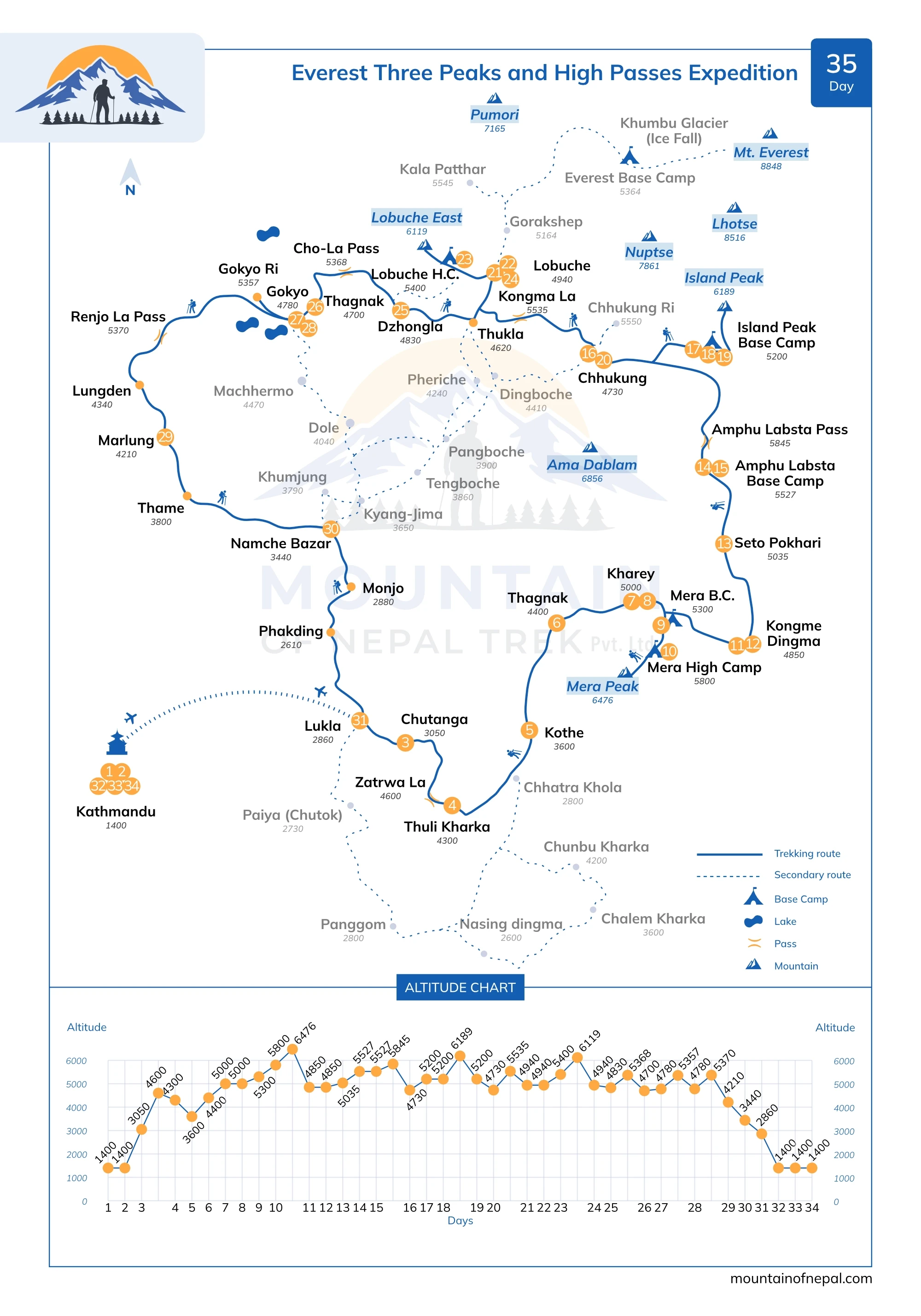
The expedition begins with a spectacular early morning flight to Lukla (2,800m),the gateway to the high Himalayas, operating either from Kathmandu (approx. 35 minutes) or Manthali Airport in Ramechap (approx. 20 minutes), this short mountain flight offersunforgettable views of towering peaks, deep-cut valleys, and rugged terrain before landing at the dramatic Tenzing–Hillary Airport. ,After meeting your trekking crew and preparing your gear, you set off on foot, leaving behind the busy trails of the Everest Base Camp route. The trail soon branches away from the main Everest Base Camp route, leading you onto a quieter and less-traveled path—an early sign that you are entering a more remote and adventurous section of the journey. The trail climbs gradually through dense Himalayan forest, where towering pine and rhododendron trees create a cool and peaceful atmosphere. The steady ascent allows your body to begin adjusting to the altitude, while the silence of the forest and the absence of crowds add to the sense of entering a more remote and untouched region. After a few hours of trekking, you arrive at Chhuthang, a small seasonal settlement set in a forest clearing, often used as a staging point before crossing the challenging Zatrwa La Pass. Overnight in a lodge at Chhuthang.
Today brings the first major challenge of the expedition as you cross the high and rugged Zatrwa La Pass (4,600m)—a demanding ascent that signals your entry into the remote Hinku Valley. The day begins early with a steady climb above Chhuthang, as the trail rises sharply through thinning forest and into open alpine terrain. As you gain altitude, the landscape changes dramatically—trees disappear, replaced by rocky slopes, windswept ridgelines, and vast mountain views. The final push to the pass is steep and physically demanding, but the reward is immediate. From the top, you are greeted with a breathtaking panorama of Himalayan giants, including distant views of Everest, Lhotse, and Makalu on clear days. It’s a powerful moment—the first real sense of being deep in high mountain country. From the pass, the trail descends into the wild and less-traveled Hinku Valley. The route drops over loose, rocky terrain before easing into gentler slopes, leading toward Thuli Kharka, a wide alpine grazing area surrounded by open hillsides. This is a true transition day—leaving behind the forested lower trails and stepping fully into remote, high-altitude wilderness. Overnight at a lodge in Thuli Kharka.
The journey continues deeper into the remote Hinku Valley as we descend steadily from Thuli Kharka, leaving behind the high alpine ridgelines. The trail winds down across open hillsides before gradually re-entering dense forest, where the surroundings become greener, cooler, and more sheltered. As we lose elevation, the path follows the natural contours of the valley through quiet woodland filled with pine and rhododendron. The sense of remoteness remains strong—this is a less-traveled route in the Hinku Valley, offering a peaceful trekking experience. Along the way, we pass seasonal grazing areas and simple herder shelters, offering a glimpse into the traditional mountain lifestyle of the region. The trail eventually meets the Hinku River, where glacial waters rush powerfully through the valley below. From here, the route follows the river upstream, with the sound of flowing water accompanying the walk toward Kothe, a small riverside settlement set on a grassy terrace beneath forested slopes. This is a more relaxed day after crossing Zatrwa La Pass, allowing time to recover while continuing deeper into the wilderness of the Hinku Valley. Overnight at a lodge in Kothe.
Today’s journey marks a gradual return to higher altitude as you leave the forested valley floor of Kothe and begin climbing deeper into the upper Hinku region. The trail follows the river upstream, with the landscape slowly opening into a more rugged and alpine environment. As you gain height, the dense woodland begins to thin out, replaced by scattered shrubs, glacial debris, and wide open views of surrounding peaks such as Kyashar (6,769m) and Kusum Kanguru (6,367m). The sense of wilderness becomes stronger, and the valley feels increasingly remote and untouched. The trail continues steadily uphill toward Thaknak, a small summer settlement set beneath towering mountain walls and used as an important acclimatization stop before entering the higher glacier zone. By the time you arrive, the environment has fully transitioned into high-altitude terrain—open, cold, and shaped by glaciers and rock formations—offering a key step in your preparation for Mera Peak. Overnight at a lodge in Thaknak.
Today’s trek begins on a rough and rocky trail, where walking becomes slower as the terrain turns increasingly rugged with scattered boulders and glacial debris. After about an hour, there is a short detour to the Sabai Tsho glacial lake area, a significant site formed by the 1998 flood event when a glacial lake burst its natural moraine dam, reshaping parts of the Hinku Valley. The route then continues deeper into the valley toward Dig Kharka, reached after around three hours of steady trekking across open alpine terrain. Following a short break, the final section involves a gradual ascent of about an hour to Khare, the main base area for Mera Peak, located beneath dramatic surrounding peaks of the Hinku region. By the time you arrive, you are fully in high-altitude terrain, marking an important stage of acclimatization before entering the glacier zone. Overnight at a lodge in Khare
Before the summit push of Mera Peak, a pre-climb training session is conducted at Khare. This essential preparation helps climbers refresh key mountaineering skills and build confidence for high-altitude peak climbing. With guidance from our experienced climbing guides, you will learn the essential techniques required for glacier travel and high-altitude climbing. This includes the correct use of crampons, harness, ice axe, and rope systems in alpine conditions. You will also train in rope team movement across snow and glacier terrain, including safe ascent and descent procedures, practicing balance, coordination, and mountain safety. The session includes an introduction to basic self-arrest techniques, building confidence and readiness for the challenges of Mera Peak climbing. This hands-on session ensures climbers are well-prepared for the technical sections of Mera Peak, including glacier travel and high-altitude movement, improving both safety and summit success chances. Overnight at a lodge in Khare
Today’s climb begins with a steady ascent over a moraine ridge, followed by a steeper scree slope as you gain height above the valley. The trail continues toward the snout of the glacier, taking approximately two hours.
From here, the nature of the climb changes and the real high alpine section begins. You gear up with crampons and harness before stepping onto the ice. After preparation, a short climb over icy terrain leads you onto a broad glacial plateau. The route then continues across the glacier toward Mera La (5,300m), which offers spectacular panoramic views of Himalayan giants including Mount Everest, Makalu, Kanchenjunga, Lhotse, Nuptse, Chamlang, and Baruntse on clear days. As there are no designated camping areas at the pass itself, you descend approximately 20–30 minutes to the eastern side to find a suitable place to set up camp on rocky terrain, often covered with snow. Overnight: in a tented Camp
Leaving Mera La behind, you begin the climb to Mera High Camp, following the route along the rocky north flank. The trail gradually gains elevation over a mix of snow, ice, and loose terrain, becoming more exposed as you move higher and requiring a steady, controlled pace. After 3-4 hours climb, you reach Mera High Camp (5,800m), set on a narrow ridge with outstanding Himalayan views. On clear days, peaks such as Everest, Makalu, and Kanchenjunga dominate the skyline. From this elevated position, tomorrow’s summit route becomes clearly visible, leading across the glacier toward the upper slopes of Mera Peak. At High Camp, you rest, hydrate, and prepare equipment for the early morning summit push. An early dinner is taken before resting for the night. Overnight: in a tented Camp
The summit push begins in the early hours of the morning, typically around 2:00–3:00 AM, when conditions are most stable. With a headlamp, you leave High Camp and step onto the frozen slopes of the Mera Glacier. The ascent follows a broad snowfield, climbed at a slow, steady pace in rope teams. Although non-technical, the climb is physically demanding due to deep snow and high altitude. Reaching the summit usually takes 4–6 hours, depending on conditions. As you gain height, the terrain opens into a vast glacial landscape leading toward the final ridge. Due to the unstable nature of the northern summit knob, the ascent is typically made to the central summit (6,461m), offering a safer and more reliable route. From the top, enjoy outstanding panoramic views of Everest, Makalu, Kanchenjunga, Lhotse, and Cho Oyu. After a short time at the summit, you descend carefully to High Camp, rest briefly, and continue down into the Hinku Valley to Kongma Dingma (4,800m). Overnight: in a tented Camp
This day is reserved as a contingency to provide flexibility for the summit attempt of Mera Peak. In the high Himalayas, weather conditions can change quickly, and factors such as strong winds, snowfall, or poor visibility may delay climbing plans. This additional day allows for a safer and more flexible summit window if needed. If the summit has already been achieved, the day can be used for rest and recovery, allowing time to relax after the physical demands of the climb. It also provides flexibility in case of delays or changes to domestic flights in the Everest region. Overnight: in a tented camp
Today’s trek continues through the remote Upper Hinku Valley, gradually ascending toward Seto Pokhari (5,035m), also known as the “White Lake.” The trail crosses glacial debris, rocky slopes, and wide alpine terrain, offering a true wilderness experience in one of the most isolated regions of the Himalayas. Seto Pokhari lies beneath towering peaks including Chamlang (7,319m) and Baruntse (7,129m). This remote and dramatic setting is a common campsite for expeditions preparing to cross Amphu Labtsa Pass or continue toward the Barun Valley. Overnight: in a tented Camp
Leaving Seto Pokhari behind, the trail enters a raw and isolated world of high alpine wilderness. The route climbs and contours through rugged terrain, crossing glacial moraines, loose scree, and occasional icy sections where every step demands focus and care. Surrounded by towering Himalayan walls and wind-swept ridgelines, you continue deeper into this completely uninhabited wilderness. The sense of isolation grows stronger with every step as the valley narrows and the terrain becomes more demanding. Beneath massive peaks and shifting cloud lines, you continue toward Amphu Labtsa Base Camp. This is true expedition terrain—remote, silent, and shaped entirely by altitude and weather. The guide team carefully manages the route, pacing, and camp selection will depend on water availability and mountain conditions. The base camp is set on stark rocky ground below Amphu Labtsa Pass at around 5,527m, marking a critical staging point before the technical crossing into the Imja Valley. Overnight: in a tented Camp
A crucial pause in the expedition. After several demanding days, your body needs time to adjust before the final high pass. You may take a short acclimatization walk above camp, gaining height before returning to rest. The rest of the day is spent preparing gear, hydrating, and conserving energy. The silence of the high mountains surrounds you—tomorrow will demand everything. Overnight: Tented Camp
The ascent to Amphu Lapcha Pass is steep, technical, and highly demanding, involving sections of rock, ice, and snow. Fixed ropes are used in exposed areas to ensure safety and steady progress. Step by step, we move higher into a dramatic high-altitude landscape surrounded by glaciers and towering Himalayan peaks. Reaching the summit of the pass is a powerful and unforgettable moment—standing at 5,845 meters between two major mountain regions, with vast panoramic views stretching across the Himalaya. The descent on the other side is equally challenging. Steep and exposed sections require careful rope-assisted movement and full concentration from the entire team. As we continue descending, the terrain gradually softens and opens into the Imja Valley. Signs of the Everest region begin to appear again—well-defined trails, trekkers, and distant lodges returning into view. By the time we reach Chhukung (4,730m), the journey is complete. After days in remote and extreme high-altitude terrain, we return to a more familiar trekking environment, with the comfort of a lodge and the deep satisfaction of completing one of the Himalaya’s most challenging crossings. Overnight at a lodge in Chhukung
Important Expedition Note
We make an alpine start, often before sunrise or even in the middle of the night. Guides assist team members and porters in carrying loads across difficult and technical terrain. High-altitude crossings involve serious objective risks such as snow, ice, avalanches, and hidden crevasses. For safety, lighter loads are carried to reduce the risk of slips and accidents. The descent is more challenging, often steep and icy. All equipment—including luggage, food, tents, and other logistics supplies—is transported across using fixed rope systems. All staff, porters, and team members also descend carefully using fixed ropes for safety.
Leaving Chhukung, the trail leads deeper into the Imja Valley, steadily gaining altitude as it moves through open alpine terrain. The surroundings become increasingly rugged and remote, with expansive views of the surrounding Himalayan giants and a growing sense of high-altitude isolation. The trail first ascends steeply before contouring along the valley floor, following the moraine of the Lhotse Glacier. The route then becomes more gradual, with a pleasant section alongside a stream as you approach the upper valley. A final push leads to Base Camp, typically reached by late morning or lunch time. Here, you arrive in a wide, open basin beneath Island Peak, where camp is set for rest and preparation at high altitude. This is the staging point for your Island Peak climb, where the focus shifts to rest, acclimatization, and preparation. Overnight in a tented camp.
After several days spent in the high-altitude Himalayan environment, including the ascent of Mera Peak and the demanding crossing of the technical Amphu Labtsa Pass, today is dedicated to rest, recovery, and preparation for the next climb of Island Peak. Your guides provide a full route briefing for Island Peak, including an overview of the climbing route, summit strategy, and safety procedures for the ascent and descend. A light technical refresh is conducted where needed, focusing on rope movement, glacier travel reminders, and equipment checks to ensure everything is ready for the summit push. However, as this skills training has already been completed during the Mera Peak expedition, the focus here is mainly on refinement rather than instruction. The rest of the day is spent relaxing, hydrating, and preparing mentally and physically for the climb ahead. Overnight: in a tented Camp
From Island Peak Base Camp, the summit push begins very early, with a pre-dawn departure around 2:00 AM. Under headlamp light, you set out across rocky scree, gaining initial elevation before moving onto steeper, more demanding terrain.The route ascends over loose rock and exposed slopes, becoming increasingly steep and technical as you gain height toward the glacier below the summit ridge of Island Peak. As you climb higher, the altitude adds to the challenge, requiring steady pacing and focus. At the edge of the glacier, you gear up—harness, crampons, and ice axe secured—and rope together under the guidance of your climbing team. Moving carefully across the glacier, you navigate crevasses, ladders, and steep snow slopes, depending on conditions, before reaching the base of the Headwall. Using fixed ropes, you ascend the Headwall—the most technical section of the route. This steep snow and ice slope (approximately 50–65°) requires steady movement while remaining securely clipped in as you climb toward the summit ridge. From here, a final push brings you to the narrow summit of Island Peak (6,189m / 20,305ft), where you are rewarded with panoramic views of Lhotse, Ama Dablam, and the surrounding peaks of the Khumbu Valley. As the summit is small and exposed, you remain clipped in while taking in the views. After a short time at the top, you descend carefully, abseiling the Headwall before retracing your steps across the glacier and down the rocky slopes to Island Peak Base Camp for the night. This long but rewarding day marks the highlight of the expedition. Overnight in a tented camp.
After a relaxed breakfast and packing, you leave Island Peak Base Camp and begin a steady descent, retracing your steps down the Imja Valley toward Chhukung. As you descend, the high-altitude silence of base camp gradually gives way to a more familiar valley atmosphere. With every loss of elevation, breathing becomes easier, and the body begins to recover from the effort of the summit push and time spent at base camp. The walk is steady and unhurried, following the same route taken on the ascent. The priority is rhythm and balance rather than speed, allowing tired legs to move safely over long downhill sections. It is a slow and enjoyable trek, and you arrive in Chhukung by lunchtime. After lunch, you can relax and rest. Overnight at a lodge in Chhukung.
Option 1: Via Kongma La Pass (High & Challenging Route)
Today you cross Kongma La Pass (5,535m), the final high pass of the journey, linking the Imja Valley with the main Everest Base Camp route. The day begins with a steady ascent from Chhukung over rocky alpine terrain and glacial moraine. The climb is physically demanding at this altitude, but by now your body is well adapted after the previous climbs and high pass crossings. From the top, you are rewarded with wide views of the surrounding Himalayan peaks and glacier valleys. After the pass, a long descent follows over loose moraine and rocky trails, gradually leading down toward the Khumbu Glacier. The route eventually joins the main Everest Base Camp trail, and a final steady walk brings you to Lobuche, a high-altitude settlement set beneath dramatic mountain scenery. Overnight at a lodge in Lobuche.
Option 2: Lower Route via Dingboche (Easier & Safer Option)
Via Dingboche (4,940m) 6-7 hours
Today you follow a more gradual and accessible route from Chhukung toward Lobuche, avoiding the high pass. The trail descends gently to Dingboche, where you rejoin the main Everest Base Camp route. From here, the trek gradually climbs higher into the Everest region, leaving the tree line behind. The trail follows a ridge above the Pheriche Valley, opening up wide mountain views. To the west, Taweche and Cholatse rise sharply, while Lobuche Peak and the snowfields toward Cho La dominate the northern skyline. Continuing toward Thukla, you reach the base of the Khumbu Glacier for a short rest and lunch stop. From here, the trail climbs to Thukla Pass, marked by memorials dedicated to Sherpas and climbers who lost their lives in the Everest region. After the memorial area, the route continues over rocky glacial terrain, and a final steady walk brings you to Lobuche, a high-altitude settlement set beneath dramatic mountain scenery. Overnight at a lodge in Lobuche.
A rest day is essential at this altitude to allow your body to properly acclimatize before the final push. While in Lobuche, you can explore the surrounding area or simply rest and recover for the challenging days ahead. The views of Pumori, Nuptse, and Everest are truly breathtaking, offering excellent photo opportunities. It is also a good time to stay hydrated and prepare your gear for the Lobuche Peak climb. During the acclimatization period, your guides will conduct a final equipment check to ensure all essential climbing gear is in good condition and properly adjusted for Lobuche East. You will already have been using this equipment during the previous peaks, so the focus is mainly on confirming that everything remains functional, safe, and suitable for the next stage of the climb. This includes crampons, boots, harness, helmet, ice axe, and layered clothing required for colder and more technical conditions. It is also an opportunity to make any final adjustments and ensure you are fully prepared for the climb ahead. Overnight at a lodge in Lobuche
Today you leave Lobuche Village and climb toward Lobuche High Camp (5,200m), preparing for the final summit. The trail ascends steadily over rocky slopes and glacial moraine, with the landscape becoming more open, rugged, and exposed as you gain altitude. As you climb higher, the air becomes thinner and the pace naturally slows. The surroundings are dominated by rugged alpine terrain, with towering peaks and broken ridgelines creating a dramatic high-mountain setting. By the time you reach High Camp, you are fully in a high alpine environment. Set on a rocky ledge beneath the mountain, the camp offers wide views of the surrounding Himalayan peaks and a strong sense of altitude and remoteness. The afternoon is kept light, with time to rest, hydrate, and make final preparations with your guides. An Early dinner and rest are essential as you prepare for the summit push in the early hours of the following morning. Overnight in a tented camp at Lobuche High Camp.
Today is the final summit challenge of your expedition as you attempt Lobuche East (6,119m)—a more technical climb that brings together the skills and experience gained throughout the journey. The day begins early, before dawn, as you leave High Camp under headlamps. Moving in rope teams with your guides, you follow a steep route over rock, snow, and ice, steadily gaining altitude in the cold, thin air. As you climb higher, the terrain becomes more technical, requiring careful footwork and proper use of crampons, fixed ropes, and an ice axe. The final section follows a narrow ridge, where steady pacing and focus are essential. From the summit, you are rewarded with outstanding views of the Himalayan giants, including Everest, Lhotse, and Nuptse, along with surrounding peaks and glacier valleys. After spending some time at the top, you descend carefully back to High Camp, retracing your steps over the same terrain, before continuing down to Lobuche, where lower altitude brings some relief after a long and demanding day. This marks the successful completion of your third and final peak of the expedition. Overnight at a lodge in Lobuche.
After the excitement of summiting Lobuche Peak, today’s trek leads you toward the final high pass of the journey, Cho La Pass. At the beginning, you make a short, gradual descent, retracing part of the main Everest Base Camp route. The trail then follows rugged alpine terrain, gradually ascending with some gentle, flatter sections, as you leave the main Everest Base Camp route and enter a quieter, more remote part of the Khumbu region. With dramatic views of Ama Dablam, Cholatse, and surrounding glacier-fed peaks, the landscape feels increasingly wild, silent, and isolated. You arrive at Dzongla by early afternoon, with time to rest and enjoy lunch before the next day’s crossing of Cho La Pass. Overnight at a lodge in Dzongla.
Today you cross Cho La Pass, one of the most iconic high passes in the Everest region, linking the Khumbu and Gokyo valleys. The day begins early from Dzongla, as you gradually ascend over rocky alpine terrain toward the pass. The trail is steep, rugged, and often icy, requiring steady footing and careful pacing in thin air. As you climb higher, the landscape becomes increasingly wild and glacial, with expansive views of surrounding Himalayan peaks and frozen terrain. The final approach to Cho La Pass is demanding, but the summit rewards you with a breathtaking 360° Himalayan panorama of snow-covered mountains, glaciers, and deep valleys on both sides of the Khumbu region. From the pass, you begin a careful descent over steep and sometimes icy terrain into the western valley, following marked cairn routes across glacier and moraine. The trail drops steadily over rocky and glacial sections before gradually easing into more stable ground. The route then continues toward Thagnak, a remote high-altitude settlement near the edge of the Ngozumpa Glacier. By late afternoon, you arrive in Thagnak, where you can rest and recover after a long and demanding crossing of one of the most iconic high passes in the Himalayas. Over night in Thagnak.
Today’s trek takes you from Thagnak to Gokyo, following the edge of the spectacular Ngozumpa Glacier, the largest glacier in Nepal.
The trail begins with a gradual walk over rocky and glacial moraine terrain, offering dramatic views of ice formations, turquoise glacial streams, and surrounding Himalayan peaks. As you continue, the route becomes more defined and gently ascends toward the Gokyo Valley. Along the way, you pass the pristine Gokyo Lakes system, where the landscape opens into a stunning high-altitude basin of turquoise waters framed by snow-covered mountains. The scenery becomes increasingly striking as you approach the main settlement. By late morning or early afternoon, you arrive at Gokyo, a beautiful high-altitude settlement beside the third lake, Dudh Pokhari. Here, you will have lunch and time to rest while enjoying the peaceful alpine setting. After lunch, you can explore the surrounding valley and lakes. If you feel strong, you may also take an optional round-trip hike to the Fifth Gokyo Lake, which takes approximately 4–5 hours depending on pace, route, and weather conditions. This excursion offers dramatic glacier views and a deeper perspective of the Gokyo Valley. O/N in Gokyo Lake
The day begins early with a pre-dawn hike to Gokyo Ri (5,357 m), usually starting around 5:00–5:30 AM. An early start is important for clear mountain views, calm weather, and the best chance to experience sunrise over the Himalaya before clouds develop later in the day. From the summit, trekkers can enjoy panoramic views of major peaks including Mount Everest, Lhotse ,Makalu and Cho Oyu. After spending time at the summit, you carefully descend back to Gokyo, where the trail is easier but still requires caution on the steep sections. Once back in the settlement, you can rest and enjoy the dramatic alpine setting of the Gokyo valley. The round-trip hike to Gokyo Ri (ascent and descent) takes approximately 2.5–3.5 hours. Over night in Gokhyo
Today’s trek begins early from Gokyo (4,790 m), leaving behind the Gokyo Lakes as we enter one of the most remote sections of the Everest region. Compared to the busy Gokyo Valley, this route is quiet and less traveled, offering a strong sense of isolation in the high Himalaya.The trail ascends steadily on stone steps and alpine paths toward Renjo La Pass (5,360 m). As altitude increases, wide views open over the Gokyo Lakes and the vast Ngozumpa Glacier stretching below. The final climb to the pass is steep and demanding, but the summit rewards us with a breathtaking panorama of Everest, Lhotse, Makalu, and Cho Oyu, along with a sweeping view back into the Gokyo Valley. From the pass, we descend into the Bhote Koshi valley. The upper section is steep and may be snow-covered, requiring careful footing. Gradually, the trail becomes more defined with stone steps and easier terrain.The landscape becomes increasingly remote, with scattered seasonal shelters and abandoned yak herder huts along the route. Human activity is minimal, and the trail feels quiet and wild compared to the Gokyo side.Occasional sightings of Himalayan tahr may be seen on rocky slopes, while yaks are more common in lower sections near the valley floor. We continue the long descent through this isolated Himalayan landscape and arrive at Marlung after approximately 7–8 hours of trekking. O/N in Marlung
Today’s trek takes you from Marlung to Namche Bazaar, following a quiet and scenic route through the Bhote Koshi valley. This is one of the less-traveled sections of the Everest region, offering a peaceful walking experience with fewer trekkers compared to the main Everest Base Camp trail. The trail begins with a gradual walk along the Bhote Koshi River, passing stone houses, yak pastures, and traditional Sherpa settlements. The terrain is steady and natural, with strong Himalayan views and a calm mountain atmosphere throughout the day. Midway, you reach Thame, a historic Sherpa village and an important cultural landmark. Thame is known as the birthplace region of legendary climber Tenzing Norgay, one of the first two climbers to summit Mount Everest in 1953. The village is also home to a centuries-old monastery and strong Buddhist heritage. Here, you stop for lunch and explore the village surroundings. From Thame, the trail continues with a gradual ascent through pine forests and hillside paths. The landscape becomes greener and more populated as you approach Namche Bazaar, with mani walls, suspension bridges, and small settlements along the way. By late afternoon, you arrive at Namche Bazaar], the main trading hub of the Everest region. Namche offers comfortable lodges, bakeries, and wide mountain views—marking your return to the main Everest trekking route after a remote valley journey.
Your final day in the Everest region begins with a gentle descent from Khumjung to Namche Bazaar, following the familiar trail you explored during your acclimatization day. Walking this route again brings a sense of familiarity, allowing you to notice details and views you may have missed earlier. From Namche Bazaar, you retrace the main trail toward Lukla, descending through lush pine and rhododendron forests, crossing the Dudh Koshi River on a series of suspension bridges, and passing lively villages such as Phakding. As you descend, take time to enjoy the scenery you may have missed earlier—the changing landscapes, flowing rivers, and distant peaks now feel more familiar, yet just as inspiring. Arriving in Lukla, there’s a mix of pride, relief, and reflection. It’s the perfect moment to celebrate the successful completion of your Everest adventure and look back on an unforgettable journey through the Himalayas. Overnight: Lodge in Lukla
Your return flight from Lukla operates either to Kathmandu or Manthali (Ramechhap Airport), with the destination usually decided on the day of your flight or sometimes just before boarding, depending on the season, weather and flight schedules. During peak trekking seasons, flights are often redirected to Manthali instead of Kathmandu. This is mainly due to air traffic congestion at Tribhuvan International Airport in Kathmandu, as well as better flight management and on-time operations from Manthali, which helps reduce delays in the busy Everest trekking period. If your flight lands in Manthali, you will continue with a 4–5 hour scenic drive back to Kathmandu on the same day. This option is often more reliable during peak seasons and ensures smoother logistics for your return.
To ensure a safe and stress-free conclusion of the trek and climbing expedition, two buffer days are kept in Kathmandu before international departure. This is especially important for itineraries that include two peak climbs—Mera Peak and Island Peak—along with the high mountain pass Kongma La Pass, where conditions can change rapidly. In the high Himalayas, sudden weather shifts are common. Heavy snowfall, strong winds, or low visibility can temporarily block high passes or delay summit attempts, making flexibility an essential part of the expedition. In such situations, an extra day may be required to wait for safe conditions before continuing. These delays are unpredictable but a normal part of high-altitude trekking and climbing. Buffer days also help manage potential disruptions from Lukla flights, which are frequently affected by weather. Combined with altitude fatigue, recovery needs after peak climbs, and long trekking days, this extra time in Kathmandu ensures safety and smooth logistics throughout the journey. If all flights operate as scheduled and the expedition proceeds without delays, these days become bonus time. You can relax at your hotel, explore Kathmandu’s cultural highlights, enjoy sightseeing in the valley, or do some last-minute shopping in Thamel. Overall, the reserve days provide flexibility, safety, and peace of mind—ensuring your combined peaks expedition ends in a secure and comfortable way. After summiting Mera Peak with views of Everest, Makalu, and Lhotse, the journey continues through the remote Amphu Laptsa Pass into the Everest region. Island Peak is then climbed using ropes and glacier techniques before crossing Kongma La Pass to join the Everest Base Camp route. The expedition concludes with Everest Base Camp, Kala Patthar sunrise, and a return to Lukla. This journey combines remote trekking, technical climbing, and classic Everest highlights in one complete Himalayan adventure.
Your Start Date is the day you land in Nepal, and your End Date is when you fly home.
If the set Everest Three Peaks and High Passes Expedition group dates don’t suit your schedule, we can offer alternative dates upon request.


 (2)
(2)  100% recommend (0)
 (0)
(0)