Need help with booking? Send us a message.
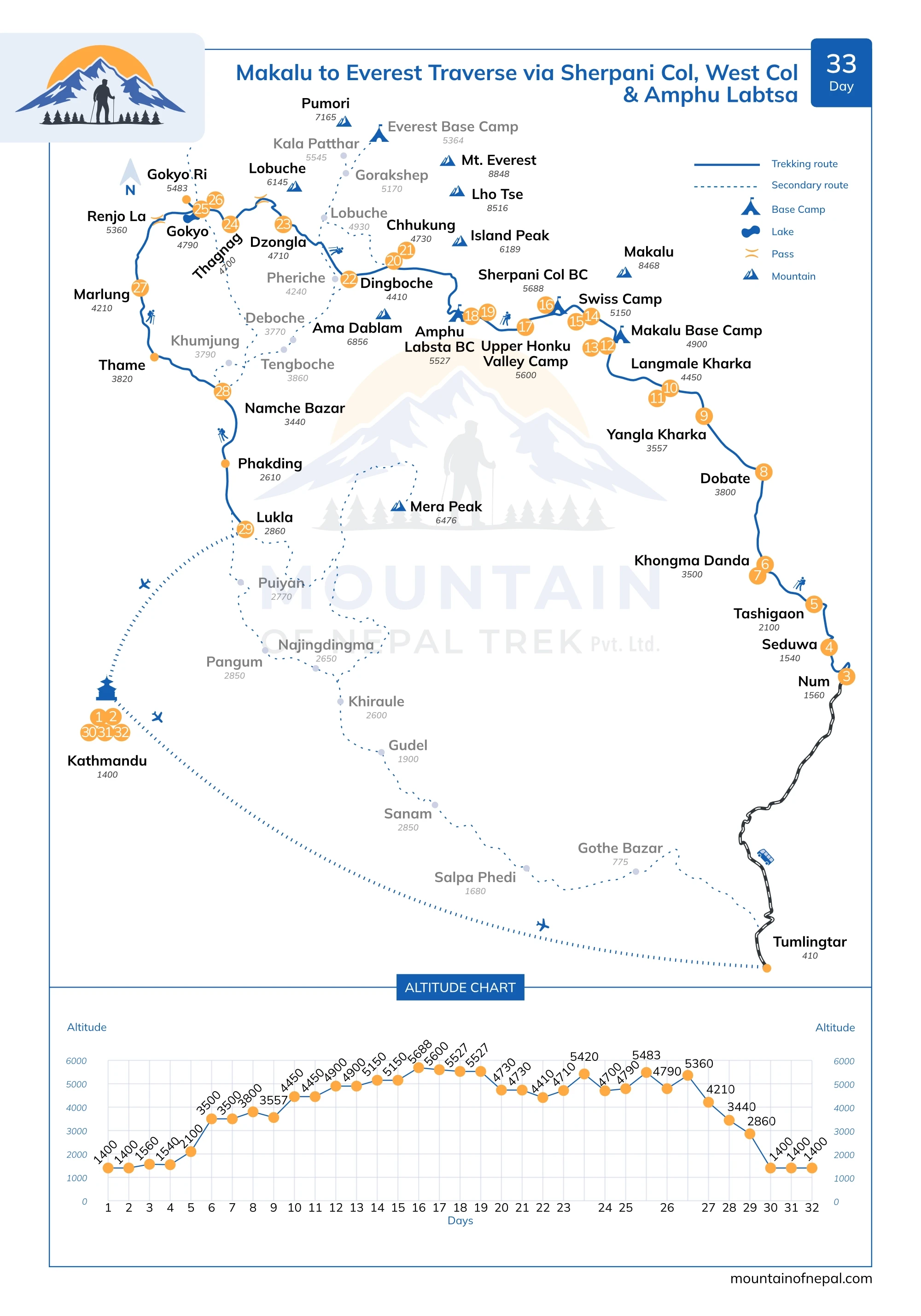
Today you take a morning flight from Kathmandu to Tumlingtar. The flight takes around 45 minutes and offers wide views of hills, river valleys, and the gradual transition from the Kathmandu Valley into the lower hilly regions of eastern Nepal. You land at a small regional airstrip surrounded by warm green hills and river valleys. This serves as the gateway to the Arun Valley Trek, the Makalu Base Camp Trek, and the Ice Col Pass Trek. After landing at Tumlingtar (410m), we meet the trekking crew and porters and complete final preparations for the trek. We enjoy lunch at Tumlingtar, then continue by 4WD vehicle toward Num. The drive first passes through the busy market town of Khandbari, then continues through terraced farmland and forested hills, offering a glimpse into rural life in eastern Nepal. The road then climbs to Chichila, where occasional panoramic views of Mount Makalu and Chamlang appear on the horizon. From here, the jeep track follows the ridge through the small Sherpa hamlet of Mure before descending toward Num. Num is perched on a promontory above the Arun River, offering dramatic views across the valley toward Seduwa and the surrounding hills. By late afternoon, we arrive at Num and check into one of the best available local lodges. After some relax, you will be introduced to your trekking staff and porters who will accompany you throughout the journey. This is a great opportunity to get to know your team, organize your gear, and prepare for the days ahead. You may also take a short walk around the village to enjoy the peaceful surroundings. This is an easy and comfortable day, allowing you to rest, adjust, and prepare for the trekking adventure ahead. From the lodge, on clear days, you may catch distant glimpses of Mount Makalu, the fifth-highest mountain in the world—an early hint of the greater Himalayan landscapes that lie ahead.
The day begins with a steep descent from Num through dense forests and terraced farmlands toward the Arun River at an altitude of 650m. This section offers a dramatic change in landscape, moving from ridge-top villages into deep river valleys. The Arun River, which originates in Tibet and flows into eastern Nepal, is one of the major Himalayan rivers and forms part of one of the deepest river gorges in the world. The crossing is done via a suspension bridge, offering impressive views of the powerful river below. After crossing the river, the trail ascends steeply on the opposite side, climbing through forested slopes and cultivated hillsides. The walk can feel warm in sections, but shaded forest paths provide relief along the way. As you gain elevation, the route enters the boundary of Makalu Barun National Park, where trekking permits are checked and registered. Seduwa is a small hillside settlement located at the entrance of the park. Upon arrival, you check into a local lodge and enjoy the peaceful mountain atmosphere, marking an important step deeper into the Makalu region.
We begin by following the trail out of the valley through rhododendron and bamboo forests, gradually gaining elevation as the landscape becomes quieter and more remote. The route continues across terraced rice fields toward Manigaon village, offering glimpses of traditional Sherpa and Rai rural life along the way. From Manigaon, the trail contours through a mix of forest and farmland as we approach Tashigaon. Tashigaon is a beautiful mountain village and the last permanent settlement before entering the high-altitude section of Makalu Barun National Park. It is an important resting point for trekkers before the challenging days ahead. Overnight in Tashigaon.
From today onward, the trail enters a more remote and rugged section. After breakfast, you start your day and leave Tashigaon, beginning the steep climb toward Khongma Danda. The trail quickly becomes more challenging, passing through dense forests of rhododendron, oak, and pine. The route ascends continuously, with stone steps and narrow mountain paths leading higher into the hills. As you climb, the air becomes noticeably cooler and the landscape more remote. There are fewer seasonal huts along the way, giving a strong sense of entering the high mountains. This section of the trek is physically demanding but very rewarding, with occasional openings in the forest offering views of deep valleys and distant ridgelines. Khongma Danda is a remote ridge-top settlement surrounded by forest and mountain scenery. It is an important acclimatization point before crossing higher passes in the Makalu region. On arrival, you stay in a basic mountain lodge and rest in preparation for the higher and more challenging sections ahead.
Today is an important rest and acclimatization day at Khongma Danda to help your body adjust to the increasing altitude (we ascended nearly 1,400m yesterday, which is a significant gain in a single day) and to prepare for crossing Shipton La tomorrow at an altitude of 4,216m, reducing the risk of altitude sickness. Proper acclimatization is essential for a safe and successful trek in the higher Himalayan region. Instead of complete rest, you may take a short hike to higher viewpoints around the ridge, which helps your body adapt while also offering beautiful views of the surrounding hills and distant peaks. The area around Khongma Danda is quiet and remote, with forested slopes and open ridgelines. From Khongma, you can enjoy beautiful views of the Kanchenjunga region to the east. It is a great place to relax, enjoy the mountain environment, and prepare mentally and physically for the more challenging days ahead. You can spend the rest of the day resting at the lodge, hydrating well, and organizing your gear. Your guide will also monitor your health and provide guidance for the upcoming high-altitude trekking days. This acclimatization day plays a key role in preparing you for crossing higher passes and reaching greater elevations safely. Overnight in Khongma Danda.
Today is one of the most challenging and rewarding days of the trek as you cross a series of high passes. From Khongma Danda, the trail climbs steeply on zig-zag paths through rhododendron forest before entering rugged and exposed alpine landscapes. The route steadily ascends toward Shipton La at 4,216m, a major high pass on the Makalu trekking circuit, where trekkers are rewarded with vast Himalayan views. This section is remote and physically demanding, with constant altitude changes, stone steps, and dramatic scenery. Weather conditions can change quickly at this altitude, so a steady and careful pace is important. From the pass, the trail descends to the sacred alpine lake of Kalo Pokhari before making another short but demanding climb to Keke La at 4,150m. After this pass, the trail descends into a quiet and isolated valley and continues toward Dobate. Upon arrival, you settle into a basic lodge and rest after a long and demanding day. Proper rest and hydration are essential as you continue gaining altitude.
After the demanding high-altitude crossing the previous day, today’s trek feels more gradual and relaxed as you descend from Dobate into the upper Barun Valley. The trail leads through alpine landscapes with rocky paths, open slopes, and scattered vegetation. From Dobate, you descend on a steep trail through blue pine forest. As you lose elevation, the air becomes easier to breathe and walking becomes more comfortable. You follow the Barun River valley, crossing several landslide-prone sections, surrounded by steep mountain walls and untouched wilderness. This remote section of the trek offers a sense of peace, with views of Peak 6 and Peak 7 along the way. Yangri Kharka is a small grazing area set in a wide valley, often used by yak herders during the warmer months. The open landscape and surrounding peaks create a calm and beautiful setting. Upon arrival, you settle into a simple lodge and enjoy a well-earned rest.
Today’s trek continues deeper into the remote Barun Valley as you move closer to the base of Mount Makalu. The landscape becomes more open and dramatic, with wide alpine valleys and towering peaks dominating the horizon. The trail follows a gradual ascent along the valley floor, passing through several yak pastures (kharkas), herder huts, and sparse vegetation. Trees are now mostly absent, replaced by rugged terrain, rocky paths, and glacial features. As you gain elevation, the views become more impressive. On clear days, you can enjoy closer views of the surrounding Himalayas, with the massive presence of Mount Makalu becoming more visible ahead. Langmale Kharka is a high-altitude grazing area set in a broad valley, surrounded by snow-capped peaks and steep mountain walls. The setting feels wild and untouched. Upon arrival, you settle into a basic lodge for the night. As you are now above 4,000m, the air is thinner, so it is important to move slowly, stay hydrated, and allow your body to adjust as you prepare for reaching Makalu Base Camp.
Today is a short acclimatization hike around Langmale Kharka to help your body adjust before the final push to Makalu Base Camp tomorrow. We begin a gradual walk up the grassy slopes above the lodge, gaining elevation slowly and safely. The route allows an ascent of over 800 meters, depending on fitness and pace. Throughout the day, you are rewarded with outstanding views of the surrounding Himalayas. The scenery becomes increasingly dramatic, with panoramic sights of Peak 3, Peak 4, Peak 5, and Chamlang, along with other surrounding Himalayan ridges. This is a relaxed but important day, giving you time to move slowly, enjoy the landscape, and prepare for the high-altitude journey ahead to Makalu Base Camp.
Today is one of the most important and rewarding days of the trek as you make your way to Makalu Base Camp. The journey takes you deeper into the upper Barun Valley up to Sherson, surrounded by some of the most dramatic mountain scenery. The trail gradually ascends along a wide glacial valley, with rugged terrain, rocky paths, and moraine landscapes. Vegetation is minimal at this altitude, and the environment feels truly wild and remote. As you move closer, the massive south face of Mount Makalu begins to dominate the skyline. Along the way, you are surrounded by towering Himalayan peaks, including Baruntse and other high ridges that define this remote region. The final approach to base camp is both exciting and unforgettable. Makalu Base Camp is set in a wide, open area with breathtaking views in every direction—glaciers, icefalls, and high Himalayan peaks create a true expedition atmosphere. Upon arrival, you settle into a basic lodge or camp and take time to explore the surroundings. The sense of achievement is immense, as you stand at the foot of one of the world’s highest mountains. This is a truly special moment of the trek—reaching Makalu Base Camp, a remote and less-visited destination, offering raw Himalayan beauty and a deep sense of adventure. We sleep two nights at Makalu Base to have opportunity to explore the area.
This is a rewarding day at Makalu Base Camp, offering time to absorb the achievement and enjoy the surrounding Himalayan panorama before beginning the descent tomorrow. Today, you take a short hike toward the Makalu Advanced Base Camp (High Camp) direction along the Makalu Glacier slopes. The round-trip walk takes approximately 4–5 hours, with an elevation gain of about 400–600 meters depending on weather conditions and fitness level. This is not a technical climb, but a gradual hike along a high ridge with your guide. The route passes through rocky moraine, sections of glacier, and open high alpine slopes, giving a true sense of the high mountain environment. From the viewpoint, you may enjoy distant views of Mount Everest and Lhotse, along with close-up views of Makalu. If you are trekking during April or May, you may encounter expedition climbers at High Camp preparing to summit Mount Makalu. This offers a unique opportunity to observe expedition life, hear about their climbing experiences, and, if welcomed, enjoy a warm tea or coffee from their kitchen staff. After this memorable experience, you return to base camp for lunch. The rest of the day is relaxed, focused on light exploration, photography, and enjoying the peaceful surroundings before preparing for the descent to lower elevations the following day.
After an early breakfast at Makalu Base Camp, we begin our trek toward Swiss Camp, gradually entering a more remote and rugged high-altitude landscape. The route follows the edge of the Barun Glacier, crossing rocky moraine, glacial debris, and uneven mountain terrain. The second half of the trek becomes more challenging, requiring careful footing with no defined trail as we traverse large boulders along the glacier beneath Makalu’s immense west face. The landscape becomes increasingly dramatic and exposed, offering a true high-Himalayan trekking experience. On clear days, there are outstanding views of Mount Everest, Lhotse, and Makalu, with surrounding peaks rising above the glacier valley. Short sections of scrambling and glacial travel are included, but the route remains non-technical with steady pacing and guidance. The final stretch leads across a rugged glacier field to Swiss Camp (5,150m). Swiss Base Camp is set among the moraine on a sandy patch, directly opposite the mighty West Pillar of Makalu—one of the rare places where you can camp so close to a legendary 8,000-meter giant. The campsite is remote and striking, surrounded by ice, rock, and towering peaks.this is an important acclimatization stop on the Makalu–Everest traverse, allowing the body time to adjust before higher passes ahead.
Swiss Base Camp is a key acclimatization point on the Makalu–Everest traverse, and today is dedicated to rest, altitude adaptation, and preparation for the upcoming Sherpani Col crossing. The focus of the day is to help your body adjust to the high altitude while keeping activity light and purposeful. After breakfast, we take a short acclimatization hike above camp on the surrounding moraine ridges. This gradual ascent helps improve oxygen efficiency while offering wide views over the Barun Glacier basin and surrounding peaks. The terrain is non-technical but requires careful footing on loose rock and uneven ground. Throughout the day, your guide will also prepare you for the Sherpani Col section ahead. This includes a safety briefing on glacier travel, reviewing rope techniques if needed, and checking essential equipment such as harnesses, crampons, and cold-weather gear. Team coordination, pacing, and high-altitude safety procedures are also discussed. The rest of the day is kept relaxed for recovery and hydration. Weather permitting, short walks around camp provide dramatic views of Mount Makalu’s West Face and the surrounding glacial landscape, reinforcing the scale of the expedition environment. This acclimatization day plays an important role in ensuring you are physically and mentally prepared for the demanding alpine crossing of Sherpani Col ahead.
(Option 2) Cross Sherpani Col and West Col, then overnight at Camp 1 (Baruntse High Camp area, ~6,100m) on the West Baruntse Glacier, approx. 9–10 hrs walk
From Swiss Base Camp, we follow a flexible two-day plan for the Sherpani and West Col section. Final decisions are made in the field by the climbing guide based on weather, route conditions, team pace (including staff and porters), and overall safety.
Option 1 – Standard / Slower Progress / Adverse Conditions:
If conditions are slow, difficult, or affected by weather or fatigue, we establish camp at Sherpani Col Base Camp / Glacier Snout Camp (5,688m). From here, the pass is approximately a 3-hour ascent. You spend the night here and continue toward Sherpani Col and West Col the following day.
Option 2 – Strong Progress / Good Conditions:
If conditions are favourable and the team is moving efficiently, it may be possible to cross both Sherpani Col and West Col in a single continuous long day. In most cases, however, you will spend the night at Baruntse Camp 1, located at West Col (around 6,100m) on the West Baruntse Glacier. The following day involves a descent into the Upper Honku Valley.
Operational Note: This section involves high-altitude travel, including glacial terrain, steep ascents, rope work, and potential abseiling. Conditions may include poor visibility and unstable weather. The guide team will manage pacing and route decisions in real time to ensure safety.
This day remains flexible depending on progress made the previous day. If both Sherpani Col and West Col were successfully crossed on Day 16, today is a shorter and more gradual descent into the Honku Valley (approximately 3–4 hours). You continues down the West Baruntse Glacier into the wide Honku Basin, where camp is established near the valley floor. If the team camped at Sherpani Col Base Camp (glacier snout) on Day 16, today becomes a longer and more demanding day (approximately 9–10 hours). We ascend to Sherpani Col, traverse across to West Col, and then descend onto the Honku side before establishing camp in the valley. In both cases, the final campsite is set within the Honku Valley, depending on conditions and team progress.
Operational Note:
This stage involves high-altitude glacier travel, snow-covered crevasse, steep ascents and descents, fixed rope sections, and possible abseiling. Weather and visibility can change rapidly, and the guide team will manage movement and safety throughout.
Summary:
Regardless of the previous day’s outcome, the objective is to position the team in the Honku Valley. If the passes were completed on Day 16, this is a shorter recovery day. If not, it becomes the primary crossing day.
You descend into the remote and untouched Honku Basin, entering a vast high-altitude landscape of ice and silence. Beneath towering ice walls and glaciated ridges lie the legendary Panch Pokhari (Five Lakes)—a group of glacial lakes scattered across the valley floor like turquoise mirrors. The landscape opens dramatically into a wide amphitheatre of peaks and ice, far from any settlements. Ahead, the imposing ridge of Amphu Labtsa Pass dominates the skyline, marking the gateway between the Honku Valley and the Imja Valley, and the final barrier before entering the Everest region side of the traverse. As you continue through this isolated terrain, you are surrounded by expansive glaciers and distant Himalayan peaks. On clear days, Ama Dablam rises sharply on the horizon, along with many other unnamed mountains that define this wilderness. Camp is established where conditions allow. Amphu Labtsa Base Camp is set on rocky ground below the pass at approximately 5,527m, serving as a key staging point for the crossing into the Imja Valley.
Operational Note
This section involves glacier travel over uneven terrain, moraine crossings, and occasional steep sections. Conditions may vary due to snow, ice, and visibility. The guide team will manage pacing, route selection, and camp placement based on safety, weather, and water availability.
Summary
A steady alpine approach through the Honku Basin leads us past Panch Pokhari and into position beneath Amphu Labtsa Pass for the next major crossing.
A crucial pause in the expedition.
After several demanding days, your body needs time to adjust before the final high pass. You may take a short acclimatization walk above camp, gaining height before returning to rest. The rest of the day is spent preparing gear, hydrating, and conserving energy. The silence of the high mountains surrounds you—tomorrow will demand everything.
The ascent to Amphu Lapcha Pass is steep, technical, and highly demanding, involving sections of rock, ice, and snow. Fixed ropes are used in exposed areas to ensure safety and steady progress. Step by step, we move higher into a dramatic high-altitude landscape surrounded by glaciers and towering Himalayan peaks. Reaching the summit of the pass is a powerful and unforgettable moment—standing at 5,845 meters between two major mountain regions, with vast panoramic views stretching across the Himalaya. The descent on the other side is equally challenging. Steep and exposed sections require careful rope-assisted movement and full concentration from the entire team. As we continue descending, the terrain gradually softens and opens into the Imja Valley. Signs of the Everest region begin to appear again—well-defined trails, trekkers, and distant lodges returning into view. By the time we reach Chhukung (4,730m), the journey is complete. After days in remote and extreme high-altitude terrain, we return to a more familiar trekking environment, with the comfort of a lodge and the deep satisfaction of completing one of the Himalaya’s most challenging crossings.
Important Expedition Note
We make an alpine start, often before sunrise or even in the middle of the night. Guides assist team members and porters in carrying loads across difficult and technical terrain. High-altitude crossings involve serious objective risks such as snow, ice, avalanches, and hidden crevasses. For safety, lighter loads are carried to reduce the risk of slips and accidents. The descent is more challenging, often steep and icy. All equipment—including luggage, food, tents, and other logistics supplies—is transported across using fixed rope systems. All staff, porters, and team members also descend carefully using fixed ropes for safety.
A reserve day in Chhukung (4,730m) is an important safety and recovery buffer after crossing Sherpani Col, West Col, and Amphu Labtsa. These high passes are demanding and weather-dependent, so delays due to snow, wind, or slow glacier travel are possible. This day keeps the itinerary flexible without pressure. It also allows essential recovery after several days above 5,500–6,000m, helping the body rest and regain energy at a lower altitude. Chhukung offers a comfortable lodge setting for rest and regrouping before continuing. It also helps you recover and prepare for the next stage, making you ready for Cho La and Renjo La passes.
Today you make a short and comfortable descent from Chhukung to Dingboche, following a well-defined alpine trail with wide open Himalayan views. The route is gradual and non-technical, allowing for an easy walking pace while leaving the high alpine zone behind. Along the way, you pass yak pastures, stone-walled fields, and scattered settlements, with continuous views of Ama Dablam, Lhotse, and Island Peak framing the valley. As you descend, the landscape slowly softens, becoming greener and more settled compared to the higher elevations. Dingboche is a well-known mountain village in the Imja Valley, and an important stop for rest and acclimatization in the Everest region trekking routes. Set in a wide mountain valley surrounded by dramatic peaks, it offers comfortable lodge accommodation and a peaceful environment for overnight stay. Afternoon is free for relaxation. You can enjoy coffee and bakery items in the village.
Leaving Dingboche, the trail climbs onto a ridge above the Pheriche Valley. From here, the landscape opens dramatically—Taweche and Cholatse rise sharply to the west, while to the north, Lobuche Peak and the snowfields leading toward Cho La dominate the horizon. Continuing with a gradual ascent along the ridge, you reach Thukla, where you pause at the foot of the vast Khumbu Glacier for a short rest and lunch. From here, the trail becomes steeper as you ascend to the windswept ridge at Thukla Pass (Dughla Pass), marked by memorial cairns built in honor of Sherpas and climbers who lost their lives on Everest and surrounding peaks. This is a powerful and reflective point along the route. From the pass, the trail continues into a more remote and open valley. The landscape becomes increasingly rugged and alpine, with wide views of glaciers and snow-covered peaks. This section feels quieter and more isolated compared to the main Everest Base Camp trail.Continuing along this high-altitude route, you reach Dzong La (around 4,710m)—a small, peaceful settlement surrounded by towering mountains. It is a common stop for trekkers heading toward Cho La Pass, Gokyo, and Renjo La. Overnight at Dzong La.
Today is one of the most challenging and dramatic days of the trek as you cross Cho La Pass, a high-altitude gateway connecting the Everest and Gokyo valleys. The day begins early from Dzongla, as you gradually ascend over rocky alpine terrain toward the pass. The trail is steep, rugged, and often icy, requiring steady footing and careful pacing in thin air. As you climb higher, the landscape becomes increasingly wild and glacial, with expansive views of surrounding Himalayan peaks and frozen terrain. The final approach to Cho La Pass is demanding, but the summit rewards you with a breathtaking 360° Himalayan panorama of snow-covered mountains, glaciers, and deep valleys on both sides of the Khumbu region. From the pass, you begin a careful descent over steep and sometimes icy terrain into the western valley, following marked cairn routes across glacier and moraine. The trail drops steadily over rocky and glacial sections before gradually easing into more stable ground. The route then continues toward Thagnak, a remote high-altitude settlement near the edge of the Ngozumpa Glacier. By late afternoon, you arrive in Thagnak, where you can rest and recover after a long and demanding crossing of one of the most iconic high passes in the Himalayas. Over night in Thagnak
Today’s trek takes you from Thagnak to Gokyo, following the edge of the spectacular Ngozumpa Glacier, the largest glacier in Nepal. The trail begins with a gradual walk over rocky and glacial moraine terrain, offering dramatic views of ice formations, turquoise glacial streams, and surrounding Himalayan peaks. As you continue, the route becomes more defined and gently ascends toward the Gokyo Valley. Along the way, you pass the pristine Gokyo Lakes system, where the landscape opens into a stunning high-altitude basin of turquoise waters framed by snow-covered mountains. The scenery becomes increasingly striking as you approach the main settlement. By late morning or early afternoon, you arrive at Gokyo, a beautiful high-altitude settlement beside the third lake, Dudh Pokhari. Here, you will have lunch and time to rest while enjoying the peaceful alpine setting. After lunch, you can explore the surrounding valley and lakes. If you feel strong, you may also take an optional round-trip hike to the Fifth Gokyo Lake, which takes approximately 4–5 hours depending on pace, route, and weather conditions. This excursion offers dramatic glacier views and a deeper perspective of the Gokyo Valley. O/N in Gokyo Lake
The day begins early with a pre-dawn hike to Gokyo Ri (5,357 m), usually starting around 5:00–5:30 AM. An early start is important for clear mountain views, calm weather, and the best chance to experience sunrise over the Himalaya before clouds develop later in the day. From the summit, trekkers can enjoy panoramic views of major peaks including Mount Everest, Lhotse ,Makalu and Cho Oyu. After spending time at the summit, you carefully descend back to Gokyo, where the trail is easier but still requires caution on the steep sections. Once back in the settlement, you can rest and enjoy the dramatic alpine setting of the Gokyo valley. The round-trip hike to Gokyo Ri (ascent and descent) takes approximately 2.5–3.5 hours. Over night in Gokhyo
Today’s trek begins early from Gokyo (4,790 m), leaving behind the Gokyo Lakes as we enter one of the most remote sections of the Everest region. Compared to the busy Gokyo Valley, this route is quiet and less traveled, offering a strong sense of isolation in the high Himalaya.The trail ascends steadily on stone steps and alpine paths toward Renjo La Pass (5,360 m). As altitude increases, wide views open over the Gokyo Lakes and the vast Ngozumpa Glacier stretching below. The final climb to the pass is steep and demanding, but the summit rewards us with a breathtaking panorama of Everest, Lhotse, Makalu, and Cho Oyu, along with a sweeping view back into the Gokyo Valley. From the pass, we descend into the Bhote Koshi valley. The upper section is steep and may be snow-covered, requiring careful footing. Gradually, the trail becomes more defined with stone steps and easier terrain.The landscape becomes increasingly remote, with scattered seasonal shelters and abandoned yak herder huts along the route. Human activity is minimal, and the trail feels quiet and wild compared to the Gokyo side.Occasional sightings of Himalayan tahr may be seen on rocky slopes, while yaks are more common in lower sections near the valley floor. We continue the long descent through this isolated Himalayan landscape and arrive at Marlung after approximately 7–8 hours of trekking. O/N in Marlung
Today’s trek takes you from Marlung to Namche Bazaar, following a quiet and scenic route through the Bhote Koshi valley. This is one of the less-traveled sections of the Everest region, offering a peaceful walking experience with fewer trekkers compared to the main Everest Base Camp trail. The trail begins with a gradual walk along the Bhote Koshi River, passing stone houses, yak pastures, and traditional Sherpa settlements. The terrain is steady and natural, with strong Himalayan views and a calm mountain atmosphere throughout the day. Midway, you reach Thame, a historic Sherpa village and an important cultural landmark. Thame is known as the birthplace region of legendary climber Tenzing Norgay, one of the first two climbers to summit Mount Everest in 1953. The village is also home to a centuries-old monastery and strong Buddhist heritage. Here, you stop for lunch and explore the village surroundings. From Thame, the trail continues with a gradual ascent through pine forests and hillside paths. The landscape becomes greener and more populated as you approach Namche Bazaar, with mani walls, suspension bridges, and small settlements along the way. By late afternoon, you arrive at Namche Bazaar], the main trading hub of the Everest region. Namche offers comfortable lodges, bakeries, and wide mountain views—marking your return to the main Everest trekking route after a remote valley journey.
Your final day in the Everest region begins with a gentle descent from Khumjung to Namche Bazaar, following the familiar trail you explored during your acclimatization day. Walking this route again brings a sense of familiarity, allowing you to notice details and views you may have missed earlier. From Namche Bazaar, you retrace the main trail toward Lukla, descending through lush pine and rhododendron forests, crossing the Dudh Koshi River on a series of suspension bridges, and passing lively villages such as Phakding. As you descend, take time to enjoy the scenery you may have missed earlier—the changing landscapes, flowing rivers, and distant peaks now feel more familiar, yet just as inspiring. Arriving in Lukla, there’s a mix of pride, relief, and reflection. It’s the perfect moment to celebrate the successful completion of your Everest adventure and look back on an unforgettable journey through the Himalayas. Overnight: Lodge in Lukla
Your return flight from Lukla operates either to Kathmandu or Manthali (Ramechhap Airport), with the destination usually decided on the day of your flight or sometimes just before boarding, depending on the season, weather and flight schedules. During peak trekking seasons, flights are often redirected to Manthali instead of Kathmandu. This is mainly due to air traffic congestion at Tribhuvan International Airport in Kathmandu, as well as better flight management and on-time operations from Manthali, which helps reduce delays in the busy Everest trekking period. If your flight lands in Manthali, you will continue with a 4–5 hour scenic drive back to Kathmandu on the same day. This option is often more reliable during peak seasons and ensures smoother logistics for your return.
Kathmandu Buffer Days (Post-Trek Safety & Flexibility)
To ensure a safe and stress-free conclusion of the trek, two buffer days are kept in Kathmandu before the international departure. This is especially important for itineraries crossing multiple high passes, where conditions can change rapidly. In the high Himalayas, sudden weather shifts are common. Heavy snowfall, strong winds, or low visibility can temporarily block high passes or make crossings unsafe. In such cases, trekkers may need to wait an extra day for conditions to improve before continuing. These delays are unpredictable and are a normal part of high-altitude trekking. Buffer days also help manage any potential delays from Lukla flights, which are frequently affected by weather. Combined with possible trail slowdowns due to altitude fatigue or recovery needs, having extra time in Kathmandu ensures flexibility and safety throughout the journey. If all flights operate as scheduled and the trek proceeds as planned, this day becomes a bonus—you can relax at your hotel, explore Kathmandu’s cultural highlights, do some last-minute shopping in Thamel, or simply rest after your trek. Overall, the reserve day adds security, flexibility, and peace of mind, making your adventure safer, smoother, and more enjoyable.
Your Start Date is the day you land in Nepal, and your End Date is when you fly home.
If the set Makalu to Everest Traverse via Sherpani Col, West Col & Amphu Labtsa group dates don’t suit your schedule, we can offer alternative dates upon request.


 (2)
(2)  100% recommend (0)
 (0)
(0)